The proposed Kalpasar Project in the Gulf of Khambhat is one of India’s boldest water-infrastructure ideas. It promises water security, irrigation and dramatically improved connectivity—but must first overcome formidable engineering, ecological and financial challenges.
By Tarak Dhurjati
Imagine building a barrier across a turbulent arm of the Arabian Sea, capturing the freshwater carried by rivers before it disappears into the ocean, and gradually creating an enormous coastal freshwater reservoir. Now imagine using the same infrastructure to connect two economically important regions that are geographically close but separated by a gulf.
This is the extraordinary idea behind Gujarat’s Kalpasar Project, formally associated with the development of the Gulf of Khambhat.
Kalpasar—its name evoking the idea of a wish-fulfilling lake—has been discussed for decades. Yet in 2026, it remains more a vision under technical development than a conventional infrastructure project under full-scale construction. According to a February 2026 report on information provided by the Gujarat government to the state Assembly, the Detailed Project Report was at the finalisation stage as of December 31, 2025. The government indicated that construction was envisaged to take about eight years after the DPR is finalised and the necessary state and Union government approvals are obtained.
That distinction is important. Kalpasar is frequently described as though its final configuration has already been settled. In reality, the concept has evolved considerably, and different published documents and reports refer to different dam lengths, reservoir capacities, road configurations and cost estimates. These figures should therefore be understood as evolving planning parameters rather than final specifications.
What has remained constant is the central ambition: to use the geography of the Gulf of Khambhat to strengthen Gujarat’s long-term water security while creating major economic and transportation benefits.
The Geography Behind the Grand Idea
The Gulf of Khambhat penetrates deep into Gujarat’s coastline, separating Saurashtra to the west from mainland Gujarat to the east. Several important river systems drain towards the gulf and its adjoining coastal zone. This creates an unusual geographical opportunity.
During periods of high river discharge, enormous volumes of freshwater eventually reach the sea. At the same time, large parts of Gujarat have historically faced water stress, drought and highly variable rainfall. The question underlying Kalpasar is therefore deceptively simple: Can some of this freshwater be captured at the point where the rivers meet the sea and stored for later use?
The engineering answer is anything but simple. The Government of Gujarat’s official Kalpasar programme describes the Gulf of Khambhat Development Project as an initiative centred on creating freshwater storage through a major barrier system in the gulf. Historical and subsequent project configurations have considered the capture of flows associated with rivers draining into the gulf region.
The Gulf of Khambhat, however, is not a placid coastal lagoon. It is a highly dynamic marine environment with powerful tidal movements and complex sediment transport. The very geography that makes Kalpasar possible also creates its greatest engineering challenges.
A Giant Water Bank for Gujarat
The most compelling argument for Kalpasar is water security.
Gujarat has transformed its water infrastructure over recent decades through the Sardar Sarovar Project, the Narmada canal system, bulk-water pipelines, check dams, groundwater recharge and local water-conservation programmes. Yet the state’s long-term demand for water continues to grow.
Urbanisation requires dependable municipal supplies. Industry requires process water. Agriculture remains the largest consumer of freshwater. Climate variability adds another layer of uncertainty.Kalpasar seeks to add a new strategic asset to this system: a very large coastal freshwater reservoir.
The principle is similar to that of an inland dam, but the setting is radically different. Instead of constructing a dam across a river valley, the project would use a barrier across part of the Gulf of Khambhat to isolate a water body from normal seawater intrusion. Freshwater flowing into the enclosed area could then progressively create and replenish a reservoir.
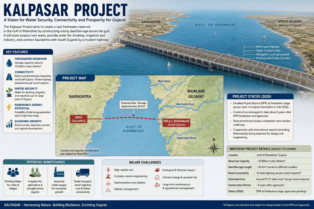
Current descriptions reported in 2026 refer to a reservoir storage capacity in the region of 10 billion cubic metres under one of the project configurations, although historical concepts have cited different capacities.
If such storage can be technically and environmentally achieved, the implications could be enormous. A reservoir of this scale could potentially provide water for domestic consumption, irrigation and industry. It could serve as strategic storage during drought years and help capture part of the highly seasonal river flows generated during the monsoon.
In an era of climate uncertainty, storage itself becomes increasingly valuable.
Climate change does not necessarily mean that every region will simply receive less rainfall. In many cases, the greater problem may be variability—longer dry periods interrupted by shorter episodes of intense rainfall.
Water systems designed for such a future must be capable of capturing large flows when they occur and storing them for use when they do not. Kalpasar’s strongest strategic argument may therefore lie not merely in supplying more water today, but in providing a buffer against tomorrow’s hydrological uncertainty.
The Agricultural Opportunity
For Saurashtra and other water-stressed regions, additional reliable water could have profound consequences for agriculture. Farmers operating under uncertain rainfall conditions tend to minimise risk. They may avoid high-value crops, reduce investment in inputs or depend heavily on groundwater. When irrigation becomes dependable, the economics of farming can change.
Reliable water could potentially support greater crop diversification, horticulture, seed production, fodder cultivation and higher-value agricultural systems. But there is an important caveat. More water does not automatically produce more sustainable agriculture. If additional water encourages expansion of highly water-intensive crops, inefficient flood irrigation or uncontrolled groundwater extraction, the long-term benefits could be diluted.
The success of Kalpasar as an agricultural project would therefore depend on combining water supply with water productivity. Micro-irrigation, precision agriculture, soil-moisture monitoring and appropriate crop planning should be integral to any future irrigation strategy.
The relevant measure should not simply be tonnes of water delivered per hectare. It should increasingly be economic value created per cubic metre of water. That would represent a fundamental shift from conventional irrigation planning.
A Highway Across the Gulf
Kalpasar’s second transformative possibility is transportation.
Today, movement between parts of Saurashtra and South Gujarat requires travelling around the Gulf of Khambhat. A direct transport corridor associated with a future barrier could significantly reduce distances between the two sides. Recent project descriptions have continued to envisage a major road connection over the dam or associated structure, although the reported number of lanes varies between project iterations and public reports. The 2026 Assembly-related report referred to a 10-lane road link. The economic consequences could extend far beyond shorter journeys.
Reduced travel times could lower freight costs and strengthen connections between industrial areas, agricultural markets and ports. Manufacturing clusters on opposite sides of the gulf could become more closely integrated.
For businesses, distance is measured not merely in kilometres but in time and logistics costs. A major Gulf crossing could therefore reshape the economic geography of Gujarat.
Industrial development, logistics parks, warehousing, tourism and new urban centres could emerge along improved transport corridors. Existing investments in ports and industrial regions could become more interconnected. This is why Kalpasar should not be evaluated simply as a water project.
It is potentially a regional economic infrastructure project.
What Happened to the Tidal-Energy Dream?
The Gulf of Khambhat has long attracted interest for tidal power because of its strong tidal dynamics. Earlier versions of the Kalpasar concept prominently included tidal-energy generation. The idea was attractive: if a major structure was already being constructed across a tidal environment, could the movement of seawater also be harnessed to generate electricity?
Research has confirmed that the Gulf of Khambhat possesses substantial tidal-current energy potential, although translating theoretical or modelled resources into commercially viable electricity requires detailed engineering and economic assessment.
Over time, however, tidal power has become less central to descriptions of the core Kalpasar configuration, and some revised concepts have treated it as a potentially separate undertaking. That may be economically prudent.
Renewable-energy technology has changed dramatically since Kalpasar was first conceived. The cost of solar power has fallen sharply, while India has built one of the world’s largest renewable-energy programmes. Any tidal-energy component would therefore have to compete economically with solar, wind and storage technologies available at the time of investment.
Tidal energy has one significant advantage: predictability. Tides can be forecast far more reliably than sunshine or wind. But tidal installations face severe marine engineering conditions, including corrosion, sediment, biofouling, powerful currents and expensive maintenance. The question is therefore no longer simply whether Gujarat can generate tidal power in the Gulf of Khambhat. It is whether it can do so competitively.
The Engineering Challenge
Here the story becomes considerably more complicated.
The Gulf of Khambhat is one of India’s most challenging coastal environments for a project of this scale. Tidal circulation moves enormous volumes of water. Sediments carried by rivers and redistributed by tides constantly reshape parts of the gulf and estuarine systems. Numerical studies of the region have consequently examined both tidal circulation and sediment transport—two factors that would be fundamental to the design and long-term operation of any closure structure.
Constructing a major barrier in such an environment requires solving several interconnected problems. First is the physical structure itself. Foundations must withstand marine conditions, currents, waves and potentially extreme weather events over many decades.
Second is sediment. When water velocities change, sediment behaves differently. Areas that previously experienced erosion may begin accumulating sediment. Other areas may experience greater erosion.
A reservoir that gradually fills with sediment loses storage capacity. But sediment management in Kalpasar is not merely a question of maintaining reservoir volume. Changes in sediment movement could potentially affect river mouths, navigation channels, ports, mudflats and coastal morphology. These processes would have to be modelled over decades.
Third is salinity. Creating freshwater storage in what was previously a marine or estuarine environment requires managing the transition from saltwater to freshwater. The time required for flushing and dilution would depend on reservoir geometry, freshwater inflows, operating rules and exchange mechanisms. Even after freshwater conditions are established, preventing saline intrusion would remain an operational requirement.
Fourth is water quality. A very large water body receiving river flows from urban, agricultural and industrial catchments could accumulate nutrients and pollutants. Reduced circulation could potentially create water-quality problems if inflows are not adequately managed.
Kalpasar therefore cannot succeed through civil engineering alone. It would require watershed management on a regional scale.
The Ecological Question
The Gulf of Khambhat is an ecosystem before it is an engineering site. Estuaries and tidal environments are biologically productive transition zones between rivers and oceans. Their constantly changing salinity creates specialised habitats for fish, shellfish, birds and other organisms. Changing the tidal regime across a large area would inevitably alter those habitats.
The key question is the magnitude of that change and whether ecological damage can be avoided, minimised or compensated.Fisheries deserve particular attention.
Many commercially important fish species use estuaries during parts of their life cycles. Changes in salinity, sediment, tidal movement and nutrient flows could affect spawning and feeding grounds. Fishing communities could consequently experience economic impacts even when they are not physically displaced by construction. Environmental assessment must therefore extend far beyond counting hectares of land affected by the dam.
It must examine the ecological functioning of the entire gulf system. The analysis should include migratory fish, benthic organisms, coastal wetlands, bird habitats, sediment transport, salinity gradients and nutrient flows. Just as importantly, these effects must be modelled over decades rather than years.
The Climate Paradox
Climate change simultaneously strengthens the case for Kalpasar and increases its risks. On one hand, a climate-resilient Gujarat will need more capacity to store water during periods of abundance.
On the other, Kalpasar itself would be exposed to climate-related changes. Sea-level rise must be incorporated into design assumptions. Extreme rainfall could produce larger flood inflows. Cyclones and storm surges could impose additional loads on coastal infrastructure.
River flows may also change over time. A reservoir whose economics depend on historical river-flow patterns must demonstrate that sufficient freshwater will remain available under future climate scenarios. This makes Kalpasar fundamentally different from infrastructure designed for a fixed environment. It must be engineered for a moving baseline.
The Question of Cost
Perhaps the most difficult issue is economics. Published cost estimates for Kalpasar have varied substantially because the project’s configuration has changed over time and because construction costs escalate over decades. Recent public reporting in 2026 has cited figures considerably higher than older estimates, with some reports discussing a project cost of around ₹1.57 lakh crore in connection with renewed consideration of the project and possible international technical cooperation. Such figures should be treated as indicative until a final DPR and approved project configuration establish an authoritative cost baseline.
At this scale, the correct economic question is not:
Does Kalpasar have benefits?
Clearly, it could. The correct question is:
Are the benefits greater than the full economic, environmental and social costs—and can those benefits be achieved more efficiently through alternative investments?
For ₹1 lakh crore or more, governments can build an enormous portfolio of water infrastructure. That could include desalination plants, wastewater recycling, groundwater recharge, canal modernisation, urban leakage reduction, micro-irrigation, distributed reservoirs and inter-basin water transfers.
Kalpasar must therefore be compared not against doing nothing, but against the best combination of alternatives. That comparison should include lifecycle costs—not merely construction expenditure.
Marine infrastructure requires continuous maintenance. Sediment management may involve recurring expenditure. Roads, gates, locks and hydraulic structures require renewal. The economic analysis should ideally examine the project over 50 to 100 years.
Kalpasar in 2026: Where Does It Stand?
As of 2026, the main Kalpasar project should still be regarded as being in the advanced planning, study and approval process rather than full-scale construction.
In February 2026, the Gujarat government told the state Assembly that the DPR was at the finalisation stage as of the end of 2025 and that, following finalisation and approvals by the state and Union governments, the project was planned for completion over approximately eight years.
Separately, recent reporting has indicated renewed exploration of technical cooperation between India, Gujarat and Dutch expertise in large-scale coastal water engineering. Reports have also referred to dozens of technical studies already undertaken and additional studies continuing into the coming years.
Meanwhile, the Bhadbhut Barrage on the Narmada, frequently discussed in the wider context of Kalpasar-related water management, has progressed separately. Government-linked reporting in 2024 indicated substantial expenditure on that project.
The distinction between the Bhadbhut Barrage and the main Gulf closure is important. Progress on one should not automatically be interpreted as construction progress on the entire Kalpasar megaproject.
Kalpasar at a Glance
Location: Gulf of Khambhat, Gujarat
Core concept: Creation of a large coastal freshwater reservoir by constructing a major barrier across part of the gulf.
Primary objectives: Water storage for domestic, agricultural and industrial use; improved connectivity between Saurashtra and mainland or South Gujarat; broader regional economic development.
Reservoir capacity: Recent project descriptions have cited approximately 10 billion cubic metres, although figures have varied across project configurations.
Dam or barrier length: Different versions have proposed different alignments and lengths; recent descriptions commonly refer to a roughly 30-km main barrier, while other renewed concepts reported in 2026 have cited longer configurations. Final specifications depend on the approved DPR.
Transport: A major road corridor across the gulf is envisaged; a 10-lane connection has been cited in the Gujarat Assembly-related 2026 project description.
Estimated cost: No single historical figure should be treated as definitive. Recent 2026 reporting has cited estimates around ₹1.57 lakh crore for a renewed configuration, subject to final DPR and approval.
Current status, 2026: DPR reported at the finalisation stage as of December 31, 2025; major construction remains subject to DPR completion and government approvals.
Indicative construction period: Gujarat government information reported in February 2026 envisaged approximately eight years after approvals and commencement.
Key potential benefits: Water security, irrigation, industrial water supply, reduced travel distances, logistics efficiency and regional economic integration.
Major challenges: Capital cost, marine engineering, sedimentation, salinity management, water quality, ecological impacts, fisheries, climate resilience and long-term maintenance.
A Better Way to Think About Kalpasar
Perhaps the most important question is whether Kalpasar must be treated as one indivisible megaproject.
There may be another approach. Instead of asking whether the entire original vision should be built exactly as conceived, Gujarat could frame Kalpasar as a Gulf of Khambhat Water, Connectivity and Climate Resilience Programme.
Under this model, the initiative could be divided into functional components. Water storage could be evaluated independently. Transport connectivity could undergo a separate cost-benefit analysis. Bhadbhut and other salinity-management infrastructure could be integrated where technically appropriate.
Tidal energy could proceed only if economically competitive. Environmental restoration and fisheries management could become dedicated programme components rather than secondary mitigation measures.
Each investment would have to demonstrate measurable value.
Modern technology also offers tools unavailable when Kalpasar was first conceived.
A comprehensive digital twin of the Gulf of Khambhat could integrate bathymetry, tidal circulation, sediment movement, river flows, salinity, water quality, fisheries and climate projections. Satellite observations could continuously monitor coastline changes.
Artificial intelligence could help analyse large environmental datasets. Hydrodynamic models could simulate thousands of operational and climate scenarios before construction decisions are made.
Instead of designing one fixed solution for the next century, Gujarat could develop an infrastructure system capable of adaptive management.
A Test Case for India’s Infrastructure Future
Kalpasar is ultimately about something larger than Gujarat. India is entering an era in which water, climate and infrastructure will increasingly intersect. The country must provide water for more than a billion people while expanding manufacturing, sustaining agriculture and protecting ecosystems.
Incremental solutions will not always be sufficient.India will sometimes need bold projects.
But boldness in the twenty-first century must be different from the megaproject philosophy of the twentieth. Engineering ambition must be matched by ecological intelligence. Capital expenditure must be justified by rigorous lifecycle economics. Climate resilience must be built into infrastructure from the beginning.
And major projects must be subjected to transparent scientific scrutiny.
Kalpasar could become one of India’s most transformative infrastructure projects. Or it could demonstrate why some megaprojects become too complex, expensive or environmentally disruptive to justify.
At present, neither conclusion is inevitable. The project’s future will depend on what the final engineering studies reveal, what the DPR proposes, how environmental impacts are assessed and whether the economics withstand comparison with alternative solutions. The most compelling aspect of Kalpasar is therefore not simply the prospect of building a dam across the sea.
It is the question the project asks:
Can India use twenty-first-century science and engineering to redesign its relationship with water on a geographical scale?
If Gujarat can answer that question while balancing water security, economics and ecology, Kalpasar could become more than a reservoir. It could become a model for how India approaches the next generation of climate-resilient infrastructure.
But for a project of this magnitude, ambition alone is not enough.
The ultimate measure of Kalpasar will be whether it can transform a remarkable engineering vision into a sustainable public asset—one whose benefits endure not merely for the next election cycle or the next decade, but for generations.
DISCLOSURE : AI tools were used for generation, review and revision of the above News Article.


